Tuesday 30 July 2019

Journey Day 15 - Golden to Savona


Woke to a sunny clear sky and the last of our brand hotel breakfasts. Tonight is an independent and our Vancouver hotel doesn't offer it.  We both actually enjoy the hotel continental breakfasts. Most of our mornings start with coffee, orange juice and cereal followed variously by bagels, English muffins, croissants, and the fun bit the waffle machine is sometimes on offer. Fruit and yogurt to finish. Occasionally they will offer crispy bacon, scrambled egg and sausages but we often ignore them as too heavy before sitting in the car for hours.

Through Mountains

Leaving Golden we were quickly in a wide flat bottomed valley with mountains rising both sides. Highway 1 was again a single carriageway at 100 kph for a while.  The 4 laning program which seems to be working along the highway in random bits continues and we had two lanes each way separated by a concrete barrier then back to single and climbing steeply

Highway 1 proceeded up and down through forested foothills with high mountains ahead, some  highlighted with patches of snow at their summits.

Another random piece of time travelling as we drive passed an insignificant road sign telling us that that we have entered a new Time zone; we have moved from Mountain Daylight Time to Pacific Daylight Time and should set out watches back one hour.


Highway 1; Trans Canadian Highway, continues to wind through the mountains with many "snow sheds" to keep it clear in snowy season.  Looking up to the tops of the mountains glaciers are visible in the saddles.


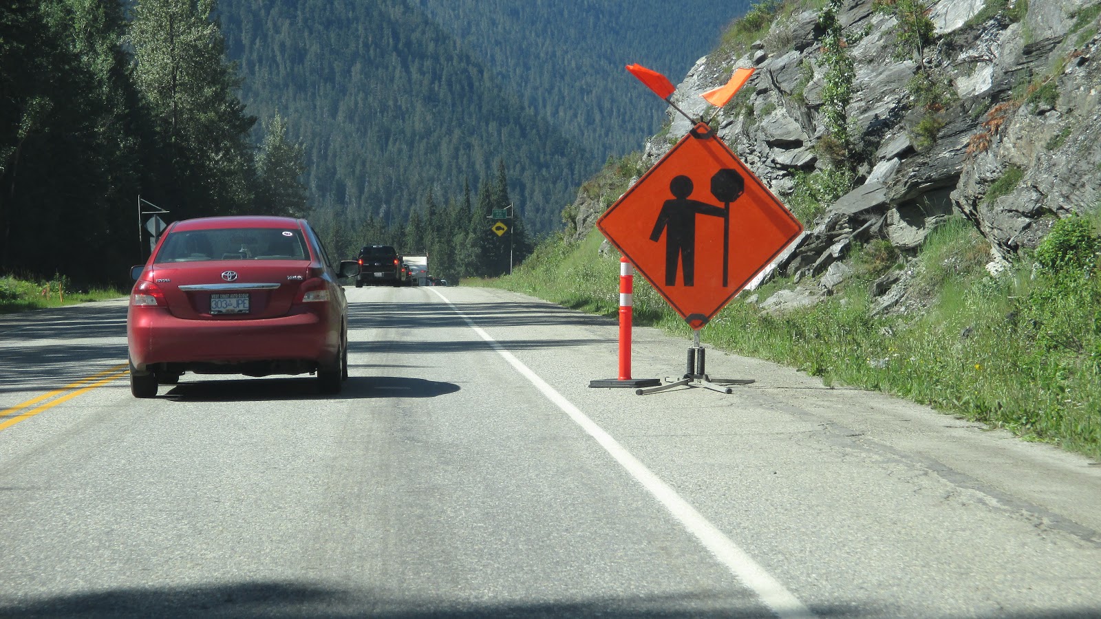
A brief period of pleasurable interesting driving is brought to an end as we enter 15 km of construction work and crawl along  at 30 - 50 kph


Rogers Pass

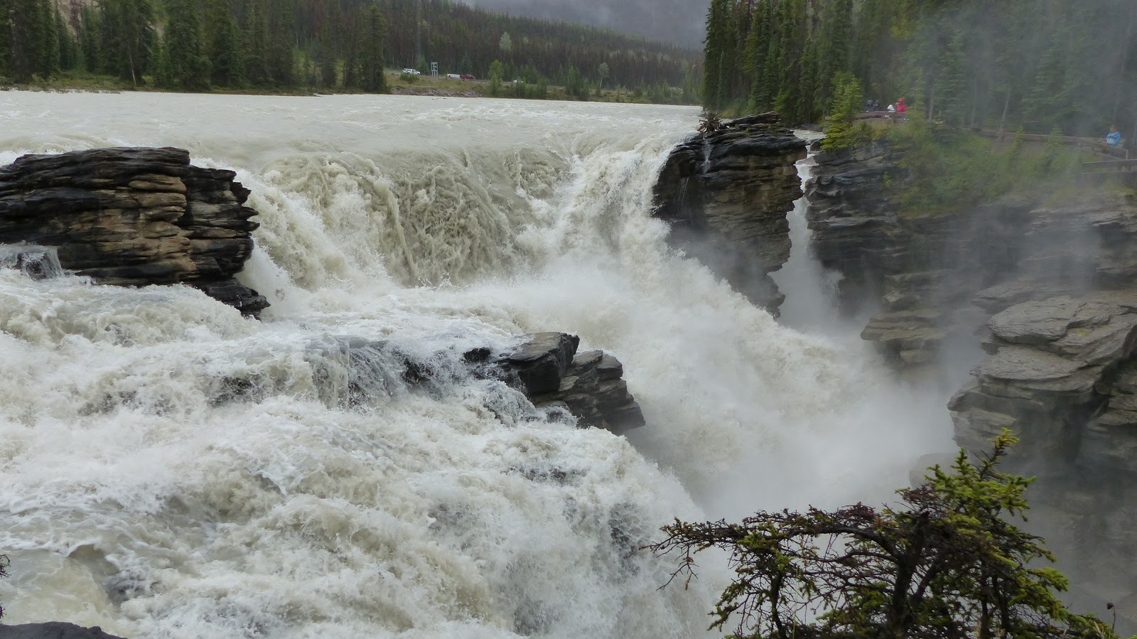
After climbing for miles we cross over Roger's Pass, so named after the surveyor who found this route over the mountains for the Canadian Pacific Railway which was the key to linking Canada together as en entity from the days when Western Canada threatened to be lost to the US.
The Visitors Center was underwhelming other than an excellent film about bears, their behaviors and how to react to them. It does play on your mind when you walk in bear country; if you get the wrong bear in the wrong mood they are lethal.
There was also a model of the railway route through the pass which used many short tunnels and clung to cliff edges; a heck of an engineering feat for the time.

A brief stop at Rogers Pass summit view point for  photos forward and back


Stopped Again

Onward and yet another construction works sign. The second sign warns of someone holding up a sign board; every roadworks has people employed at both ends holding a small diamond shaped sign on a post, usually yellow with the word SLOW, and waving if people haven't noticed them. I does seem a soul destroying job standing in the heat of the day dress in vivid yellow overalls ans wearing a hard hat.


It was lunchtime and we had nothing with us so we pulled off to Revelstoke town. It was an attractive little town with lots of shops but nothing obviously a sandwich shop. After a tour twice around, we stopped at a bakers but, though they had amazing looking pastries, they only had a few wraps and bits left. We settled for a Three Meats Croissant and a huge Almond Croissant.

Meadows in the Sky Parkway

Returning to the highway, and our National Parks pass still valid till 16:00, we entered Mount Revelstoke National Park of which the central point is high meadows which are covered in snow for much off the years but burst into flower meadows in summer. The Meadows in the Sky Parkway is a  26 km zig-zag climbing road up to the car parks from which a shuttle runs to the summit meadows.

Various pullouts allow views to the surrounding mountains including the Snow Forest mountain ridge below which the Columbia River makes it's way along the valley bottom.

To road edges  as we climb are full of flowers and promise much of the meadows to come.


Unfortunately after 26 km of climbing we encounter a full car park and realise that we must abandon our visit to the meadows as time does not allow walking from further roadside parking and waiting for shuttles. Still, the Parkway drive itself has been lovely and we have had a taste of the meadows in the roadside verges.

Descending again we stop and walk 100m to Panorama Point, a gorgeous spot which we have to ourselves.  The distant mountains are stunning and the ground around us full of flowers.

Half way down, we pull over and in our now habitual way reverse onto a view and sit on the tailgate to eat our meat and sweet croissants which were really good. Though the the Three Meats one did inevitably have a slice of white cheese on it. What is it with this side of the Atlantic?

Highway 1 to Savona

Back at the park entrance it was now 1:30 and we still had 250 km to go so it was time to drive and reduce our photo stops.  The hills became lower and crops and the occasional vineyard appeared in the valleys.  We passed several big lakes which advertised beaches and the feel was that they were the equivalent of us going to the coast for the day- seaside holidays inland.

Still we continued West on our travels along Highway 1. The land became more parched and the hillsides barren. Oddly, the contour and colour of the hillsides became very reminiscent of North Western Scottish Highland and lochs.

With less roadworks and concentrating on keeping moving we arrived at our lodging in Savona in good time. Margaret and Domm run the Lakeside Inn and Margaret welcomed us enthusiastically and showed us to our room on the front of the house with use of the veranda.

End of Day

Self catering tonight, we drove to a Italian takeaway run by the very Italian Maria and ordered pizza. While the pizza was prepared we drove to the other end of town to a small Supermarket who had just what we wanted; Beer, Milk and Ice Cream. It seemed an excellent supermarket for the community.
Back to the room to set up, we though we may eat in the garden at back which runs down to the lake but the time of evening the flies were lifting from the grass and we've both had so many bites in the earlier parts of this trip that we didn't fancy it.
I nipped out and collected the pizza and we settled in two comfy chairs on the veranda, first to eat and then, still connected to WiFi,to write and research.

We have often seen people passing warm evenings outside there houses sitting in covered verandas and now understand why. It was very pleasant.

After the brands, who for some reason insist on putting warm quilts on beds when the nights are warm, it was refreshing that here we had a simple blanket with a top sheet and with an overhead fan available, we turned off the air-con and had a good night's sleep with gentle air movement.

My last action before retiring was spending a while calculating our remaining fuel requirement, a sure sign we are reaching the end of our journey. The rental is full to empty and I don't want to return it with anymore fuel than I have to.

Today's Statistics

Final Timezone crossed

Statistics: Miles today: 295; Miles so far: 3486 ; Fuel added so far: 308.5 litres, 67.9 imp gals; Provinces: British Columbia; Time Zone: UTC-6 Mountain Daylight Time (MDT) and UTC-7 Pacific Daylight Time (PDT)


Sunday 28 July 2019

Temporary Post - blog progress

As you probably appreciate, writing this takes quite some time and the last couple of days have been short on available laptop time.
I have just posted another day and will try to complete the last travel day over the next 48 hrs.
Thanks for your interest and please keep checking back.
Ged & Lynne

Friday 26 July 2019

Journey Day 14 - Moraine Lake to Golden

Lake Moraine

Morning arrived and I thought I could hear rain pattering on our roof but opening the blind on our huge picture window revealed a dry morning; however, the wind was still blowing and the surface of the lake every bit as choppy as last night
Still, we a reason to be here was to be out before the crowds arrived so 06:30 we dressed and headed out; Amazingly, at 07:00, the car park was well filled and people were already milling about.
Moraine Lake car park at 7am

The Rock-pile

The best views of the lake are from the top of the Rock-pile and that is where we headed for a hopefully un-crowded view of the valley. It was easy to move around at the top but it was still amongst people and waiting to get into a position you wanted for a particular shot. It was definitely worth being there early. So much rain had fallen that a couple of the best positions were flooded.
Looking up the fells from the steps
The sky was broken with patches of blue but was largely clouded and only slivers of sun made it to the Lake and valley sides.


Lakeshore Walk

After descending the Rock Pile we walked the 1.2 km trail along the lake shore.


Looking back up the lake toward the sun, the blue colour in the water is absent and it presents a more broody view.

rapids where the creek enters the head of the Lake

View North with cliffs silhouetted
Walking back to the Lodges, an icefield is visible above the Lake on the far side which is inaccessible.

Breakfast and Checkout

Back from our walk we headed into breakfast in the main lodge building around 09:30.
It continued windy with snatches of sun as we walked back to our Lodge at the far end of the row. I still love this lodge; it feels comfortable and welcoming as soon as you walk through the door and then the big picture windows, albeit through trees; over the blue of the lake and the high hills.
We were really sad that the wind meant that the canoes on the Lake were suspended again. We had both been looking forward to that as a special part of the trip. It is good that it clearly would be unsafe; better than wishing and wondering or resenting a close that you don't agree with.

We had also expected to go on a hike before we left the area but neither of us feel like it. Time is moving on so we shower and pack and just about make checkout 11:00. We wanted to call in the cafe shop for some sandwiches for lunch and went before checking out so we had our key for 10% discount.

rock pile #3

Car packed and ready; we couldn't resist a third trip up the rock pile. Moraine Lake is stunning even without the sun and we visited various view point positions though now moving among large crowds. We still managed to get good photos, I thing I took about 40 on one camera so the selected ones are among the best. 

Our final shot, below, we searched out as matching the front cover of The Rough Guide Canada which Lynne has had as a constant companion.
Match to The Rough Guide to Canada front cover


Moving On

We only had about 60 miles to travel today but with the weather not encouraging us to be out walking  we decided to head South again toward Banff and pick up part of the Bow River Parkway which we had bypassed on the way into the area having stayed on Highway 1.
Bow River Road North
We were stopping for fuel in Lake Louise town but after missing the garage turn, I managed to miss interpret directions and ended up on Highway 1 North. Not Happy! Fortunately, there was a turn off not far out of town and we were soon back and filling up. Fuel here in Alberta has been a little dearer than the last couple of Provinces but having pre-authorised $50 I went ahead filling to over 3/4 full at $1.22per litre (more on this tomorrow).

Bow River Parkway

Back down Highway 1 South for some miles and we turned North again on the Bow River Parkway.  This is a much smaller road with a reputation for wildlife sightings,though most of these were on the section South of us.

Moraints Curve

All the way across Canada we have seen and heard rail freight being used as a primary mover. There are trucks on the Trans Canadian Highway, but nothing like the density of European countries or indeed the USA on long distance trunk roads.
We halted at Moraints Curve view point on the Bow River road to see a wonderful vista of a wide curving river backed by heavily forested hillsides running up to the exposed tree line on the mountains which in turn were topped by highlights of white snow.  In addition to the natural treats, a long freight train with double container loads rumbled and squealed past for ages. The locomotives had long disappeared around curves up the valley while the rest of the train continued to rattle past.
Moraints Curve

Wildlife

Driving on suddenly noticed two Elk up the hill side on the far side of the road. A third, a female appeared on the road ahead and had to be avoided by car which had passed me. Somewhat spooked she ran different ways on the road before heading up the hill to he male friends.
Telephoto lens used

Trans Canadian Highway


AT the top of the Bow River Road we again joined Highway 1, coincidentally at the same junction we left it to head up to Jasper.
Time had moved on by now and we settled down to cover some miles.

Rogers Pass

We briefly visited the Visitor Centre at Rogers Pass where after years of surveying, a pass had finally been found to drive the Trans Canadian Railway through. The engineering for so long ago withbasic tools was amazing.

Spiral Tunnels

At first, the railway descended to the West from Rogers Pass with various escape lines and such but repeated train wrecks led to a new solution.
Two loops are built into the mountain so that the trains can spiral down much more gently. We stopped at the Spiral Loops view point for along time as we knew a train was coming but it was a lot longer than intended. Unfortunately, the trees have grown add the bottom tunnel exit is barely visible.
On this picture, the locomotives are running right to left just visible in the bottom centre of the photo. Thy have completed the loop in the mountain and the rest of the train can still be seen entering the top tunnel and crossing above the tunnel exit. Quite remarkable how the pull can continue in such a loop without dragging things off or losing power.
Spiral Tunnels

End of Day

The rest of the afternoon we just drove and arrived at Golden. The hotel is on a typical hotels and garages scrappy strip by the Highway and we couldn't see anywhere we fancied eating. We got in the car again and headed into Golden downtown which turned out to be a very pleasant small town with a cinema and nice centre.
Near the bridge over the river was a small restaurant,The Island, and we enjoyed a very good pasta and a beer.
Chatting to our server, she was saying how lucky we were that it had been so wet this year because by now the whole area normally smells of wood smoke from forest fires. 

Blog Progress

Getting behind on blogging. This one is going out 24 hours late and I haven't even started writing Day 15 yet..

Today's Statistics

Statistics: Miles today: 160; Miles so far: 3191 ; Fuel added so far: 308.5 litres, 67.9 imp gals; Provinces: Alberta & British Columbia; Time Zone: UTC-6 Mountain Daylight Time (MDT)


Thursday 25 July 2019

Journey Day 13 - Jasper to Moraine Lake

Jasper

Our luck has finally run out on the good weather and we awoke to rain and cloud down on the mountains.  We had been aware that the weather was going to deteriorate but the suggestion had been thunder storms. 

We paid for breakfast at the Crimson where we were staying rather than spend time hunting something down. We mostly go for breakfast included accommodation.

At tonight's destination, Moraine Lake Lodge, there is only a white table restaurant which is not our preference and is also very expensive; so we are self catering this evening with no microwave so it has to be cold. The excellent bakers sourced a large chicken samosa and a pizza pretzel and the supermarket a tray of raw vegetables with a ranch dip and a tray of fresh fruits for desert. We already  had wine from a liquor store; still can't get used to not buying alcohol in a supermarket.

Finally stocked up, we headed out of town to retrace our steps down highway 93A.

Highway 93A

Somewhat different visibility from yesterday through mist and around wiper blades, we still kept a sharp eye out for wildlife hoping against hope that we may spot the bear again.

Athabasca Falls

At the Southern end of the road before joining the 95 is Athabasca Falls. We deliberately left this yesterday so that we had something good left to look at today and water falls are OK in poor weather.
Athabasca Falls was more than ok. I believe they must always be powerful but following the overnight rain they are awesome in visual power and sound. We spent a while here crossing from one side to the other on a bridge and seeing all sorts of different angles into the deep canyons the falls have carved.


At the bottom of the Falls, raft trips were setting off into an exciting looking ride.


Highway 95

200 metres from Athabasca Falls we rejoined the 95 on a duel carriageway heading South toward Lake Louise town.

Watching the sides for animals as well as the road we pushed on. Wipers mostly on fastest intermittent but with the high mountains shrouded in mist.

Tangle Ridge & Mushroom Peak

For a time it looked brighter but as we climbed the temperature dropped from 11 through 9 to 7.5C and combined with rain and wind it was freezing to step out to take photos.

Waterfalls & Lunch

We stopped for lunch across from cliffs covered in waterfalls which had not been there yesterday.
This spot may have been Weeping Wall but we're not sure.


Mistaya Canyon

At a pullout for Mistaya Canyon I stopped to get photo's of the edges of icefields


Peyto Lake

Passing the end of Peyto Lake with it's permanent blue due to Rock Flour washed from the glaciers feeding it.

Crows Foot Glacier


Herbert Lake

The first lake we visited at the start of the day yesterday which we were so captivated by. Today it doesn't have the wonderful backdrop. 

Around 3:00 it seemed to be drying a little but the rain continued albeit with breaks.

Lakes Louise and Moraine


Lake Louise

Our destination was Lake Moraine but to get there we had to o via Lake Louise town. Signs on Highway 95 warned that parking was full and the shuttle must be used to visit, however, as we were through traffic we drove down passed the town and were steered toward the Lake in a one way flow. The turnaround to continue to Lake Moraine was through the main car park for Lake Louise and to our surprise we saw a couple of spaces.
We had wanted to see Lake Louise but had written it off as impractical given the time involved in shuttles etc so we were delighted to park up and walk 10 minutes to the Lake head. 

Pleased with our luck and having taken in Lake Louise we continued a further 14 km down the valley to Lake Moraine, our destination.

 Lake Moraine

Tonight we have treated ourselves to a one off expensive treat and are staying in a Lake Moraine Lodge. We calculated that staying in the heart of an area that is difficult to get to in daytime traffic was in effect giving us an extra day in the Rockies. Also, to be in this remote area when it was quiet was a delightful thought.
Reception tell us the weather will improve tomorrow and  we hope to be out on the Lake in a canoe which is part of the deal. A little worrying as the wind is whipping up waves on the lake and canoes have been suspended today.


At the top of the Lake is a massive rock pile which was dumped by a glacier and the top of this is where the best views of Lake Moraine are to be found.

Lodge

Our lodge is amazing with a massive picture window looking through the trees to the blue water beyond. We even have a log fire which,when we read of it,we thought there was no way we'd get to use; but, the temperature is 6 outside to fire lit, complementary red wine in hand we settle for the evening.

Our in lodge picnic meal works well and we enjoy a relaxed evening with the pine wood fire crackling away.

We did pop out for a short walk before finally settling; even at 10pm there were still visitors in the car park. Disn't stay out long, it's very cold now.


Today's Statistics

3000 miles passed

Statistics: Miles today: 201; Miles so far: 3031 ; Fuel added so far: 267.5 litres, 58.8 imp gals; Provinces: Alberta; Time Zone: UTC-6 Mountain Daylight Time (MDT)